-
 Widespread drought is expected to drive a challenging wildfire season across Colorado and the region.
 -
 Cody Moser with the federal Colorado Basin River Forecast Center said in a monthly briefing Tuesday that just 1.4 million acre feet of Colorado River water is expected to reach Lake Powell through July. That's less than a quarter of what's considered normal.
 -
 Hydrologists working high in the Rocky Mountains have measured what they say is Colorado's driest winter of snow moisture on record. That means water shortfalls are likely ahead as drought persists across Colorado and other western states.
 -
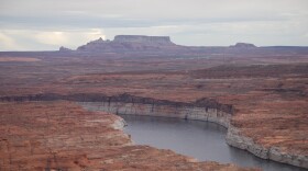 Record-low snowpack across the Upper Colorado River Basin will likely translate to poor conditions for spring runoff, and could mean emergency action to supplement low water levels in Lake Powell.
 -
 Estevan López, New Mexico's water negotiator, said talks resumed March 2, and the upper and lower basin states are using a short-term pitch from Nevada as a starting point.
 -
 Colorado's state climatologist said long-range forecasts are also not signaling a 'Miracle March.'
 -
 Drought is on everybody's mind right now as the State of Colorado reckons with a snowpack that is about half of normal.
 -
 Declining snowpack is creating new challenges for irrigation, livestock, and traditional food systems in tribal communities
 -
 Colorado and other Western states are experiencing the worst snow drought in decades, not because of dry conditions but really warm temperatures that change snow to rain.
 -
 At less than 140,000 square miles, snow cover across the region was the lowest ever recorded on February 1 in the satellite record, which goes back to 2001. The National Oceanic and Atmospheric Administration (NOAA) and the National Integrated Drought Information System (NIDIS) call it the “worst snowpack on record.”
© 2026

NPR News, Colorado Stories
Play Live Radio
Next Up:
0:00
0:00
Available On Air Stations


